Ukraine Conflict: Full Frontline Update
Table of Contents 📖
"This is the absolute optimal time for the Russians to attack and make as much ground as possible."
Hello Team
🎦 00:00-01:06⏩
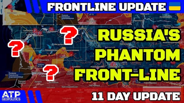
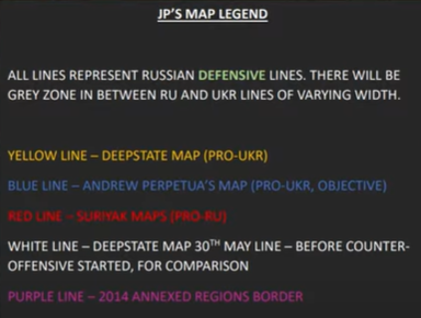
Jonathan welcomes viewers, noting that he was out late and didn't update the map himself last night. He clarifies that he always updates the map, regardless of what's happening on the frontline, and dismisses pro-Russian commenters who suggested otherwise as "eejits". He confirms that he's added to the mapping work JR did for him while he was out, and points out the situation on the ground is "fairly dynamic". He reminds viewers to refer to the on-screen key for an explanation of the map's symbols.
Return to top⤴️
📍 FRONT-LINE UPDATE -🗺️ MAP LEGEND
Northeastern Axis: Kupyansk-Svatove-Kreminna
🎦 01:06-05:10⏩
Jonathan starts at the northeastern axis. He observes that the map shows mostly Russian advances (red and deep orange pins) in this area, which has been stable for a while. He notes an uptick in activity, particularly around Kotaly Rivka, Kizlovka, and Tobayevka.
- Euromaidan Press reports that Russian troops, after a period of regrouping and rotation, have resumed offensive operations in the Kupyansk and Lyman sectors.
- Kharkiv Oblast Head, Oleg Sinyebov, confirms this, stating the Russian offensive targets Ukrainian defensive positions in those areas. He attributes this to two months of Russian troop rotations and replenishment after suffering losses and degraded combat capability due to the effectiveness of Ukrainian armed forces.
- Jonathan expresses concern, given Ukrainian mobilization issues, that this could signal difficult times ahead.
- He reports that the Russians, having rotated units, brought in replacements, and conducted training and coordination, launched a new series of assaults: five in the Kupyansk direction and nearly 15 on the Lyman axis on the 29th of April, followed by nine more on the Kupyansk axis on the 30th.
- The Lyman front was calmer, suggesting the Russians are testing and probing Ukrainian defenses for weaknesses to exploit later.
- Sinyebov estimates current troop numbers in the Kupyansk area are similar to 10 months ago, when the last major assault began - around 100,000 total forces, including approximately 50,000 combat troops.
- An additional 20,000 Russian troops remain in the northern part of the Kharkiv region.
- Jonathan acknowledges the Ukrainians have stabilized the situation in the Synkivka area. However, he believes the Russians are probing for weaknesses, and all map sources agree on Russian gains in the Kizilivka direction.
- Suriat Maps shows small Russian advances west of Kizilivka and south of the locality towards Koteleryivka over the past two days.
- Further west of Kreminna, near Turskiy Terny, Yampolivka and the Zhebebsk River, there's good news: Ukrainians have regained some territory (potentially two separate instances of Ukrainian gains).
Southern Bakhmut: Chasiv Yar Canal Dispute
🎦 05:10-11:12⏩
Jonathan apologises for any difficulty speaking, blaming "self-inflicted" damage from a night out involving "too many pints of Black Sheep". Moving south, past the Sverdlovsk line towards Chasiv Yar and west of Bakhmut, he reports Russian advances north of Ivanovska, on the high ground (Mount Baba) south of the canal micro district.
- Suriat Maps, after initially incorrectly showing the entire area under Russian control, now shows the Russians advancing south in the nature reserve area and along the forest line north of Ivaniske.
- Depending on the map, the Russians are either advancing on lower ground but not yet higher ground (other mappers) or have already made significant advances through the wooded area on higher ground and are pushing far along on the lower ground up to the canal (Suriat Maps).
- This discrepancy stems from a debate between Julian Roepke and Andrew Perpetua:
- Roepke, a journalist for Germany's Bild newspaper, claims that Russian forces crossed the Chasiv Yar Canal 1km southeast of the town and will soon enter the settlement from either the east or the south.
- Perpetua criticizes Roepke's reporting, stating he would be a better journalist if he quoted his sources and included caveats.
- Jonathan sides with Perpetua (noting that he relies on him a lot and that he is very careful with making changes to his maps), providing a link to a video Perpetua shared (credited as coming from the "official text operators of the...attack drones of the 18th Slavic Brigade of the NSU") showing a Russian infantry patrol being bombed.
- Perpetua questions why Roepke didn't mention there were no Russian soldiers in the video footage, and suggests that Roepke only geolocated it after "Geek" (a member of Perpetua's team) posted the location.
- Roepke responds that he geolocated the footage and did the analysis himself, accusing Perpetua of inventing things to discredit him.
- Perpetua counters, stating that if Roepke did his own analysis, why didn't he mention there were no Russian soldiers in the video? He also points out that the video was released the day before Roepke's claim, but Roepke only got around to geolocating it after Geek posted the location.
- OSINT source Martin Tuttera clarifies the situation: a Russian infantry patrol, hiding in pipes around the Chasiv Yar Canal, was bombed. Tuttera suggests Roepke chose to frame it as Russians crossing the canal and imminent entry into the settlement because it "sounded much less dramatic".
- Jonathan emphasizes this point, as Suriat Maps appears to have based their mapping change on this questionable evidence. He concludes it's highly unlikely the Russians have either crossed the canal or have robust control over the land up to the canal. He predicts the Russians will likely take the land and Chasiv Yar, but they aren't there yet, and it's "disingenuous" to suggest otherwise. He believes the area is a grey zone, with Ukrainians actively using drones to target any Russian presence.
- Suriat Maps' own summary states that the Russian army made new advances south of Mount Baba and reached the water channels for the first time. Clashes with Ukrainian forces continue for control of the high ground to the north.
- Jonathan reiterates his belief that the Russians will likely take the ground, but they don't control it yet.
Avdiivka: Russian Advances and Analysis
🎦 11:12-20:01⏩
Jonathan shifts focus south to Avdiivka, describing the situation as "pretty dynamic" with Russians making good progress in taking territory, though likely suffering troop and equipment losses. He believes the Russians consider this a beneficial calculation.
- Suriat Maps shows large Russian gains in the area of Novokalynove, while Andrew Perpetua and Deep State Map show some gains and changes.
- Jonathan notes Russian gains around Novokalynove and further out northwest from Okhretina (or Ochiratina), on the way to Novaya Oleksandrivka, describing it as "a little bit worrying".
- He's heard claims that Ukrainian fortifications in this area are lacking, but cannot confirm.
- Suriat Maps also shows Russian gains around the village of Solovyove, extending south.
- Jonathan highlights Suriat Maps' analysis of the situation:
- The breach of Ukrainian defenses in Ocherutina has created confusion in the Ukrainian command, allowing the Russian advance to continue.
- The capture of Ocherutina is similar to the capture of Popasna in 2022, which enabled the Russian advance toward Bakhmut, Soledar, and the strongholds of Lysychansk and Severodonetsk.
- Following the capture of the new bastion around Ocherutina, Suriat Maps predicts Russian advances will likely exploit the high ground along the railway line that extends north towards Nova Oleksandrivka.
- Specifically:
- The Russian army advanced west and south of Solovyove toward Sokyil and Novopokrovsk.
- Troops continued the advance northwest of Ocheratina, taking control of plantations near the eastern outskirts of Novo Oleksandrivka.
- Russian forces took control of Keramik following Ukrainian withdrawals towards Orkanelske, increasing pressure on the almost-encircled central trench system in that area.
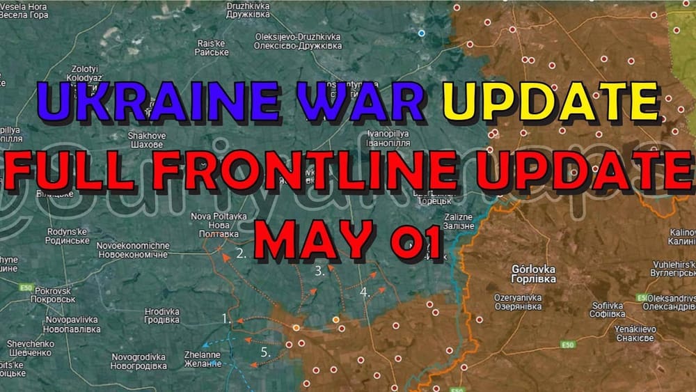
- Suriat Maps predicts (based on a pro-Russian source):
- The Russian army will continue advancing west towards Povrez (Point 1 on their map) while maintaining their position at northern Ocheratina.
- Taking Povrez allows them to establish fire control over Ukrainian troops east of the Kalytska Reservoir, hindering Ukrainian logistics in the area, and enabling the Russians to advance westward towards Povrez and Zhelane.
- Simultaneously, Russian troops will advance along two major axes:
- Towards the road junction on highway H32 (connecting Prokrovsk with Kostyantynivka). This would cut a main supply route to Kostyantynivka, leaving only the road to Kramatorsk.
- North, targeting the town of Kalinove. This push, originating from Keramik, Novaya Konovaye, and Ocheratina, along with the capture of Oleksandropil and Panteleimonivka, would allow them to reopen access to the H20 highway.
- After Kalinove, the Russians will likely push north toward Zorya, though the Kreban Bik Reservoir poses a natural barrier and leaves them vulnerable to bombardment from Kostyantynivka.
- At the same time, they will consolidate and expand control over the highway crossing (Point 2 on their map).
- This advance will be complex due to extensive Ukrainian defenses, but if successful, will place them on the southwestern outskirts of Kostyantynivka, leaving the Ukrainian-held areas of Toretsk, New York, and Shcherbinivka in a semi-encirclement with only one remaining supply route.
- The capture of Chasiv Yar in the following months would leave Ukrainian troops in a critical situation, and likely trigger a Russian attack on New York, pushing from the 2014 defensive lines.
- Jonathan summarizes, emphasizing the possibility of the Russians interdicting the highway, moving up towards Kostyantynivka, and, if they take Chasiv Yar, advancing down south, making New York and Toretsk vulnerable by cutting off their supply lines, creating an operational encirclement from the north and south.
- He acknowledges the Ukrainians are likely in an operational withdrawal if they lack strong fortifications in this area. He speculates they may be building defenses further back (near Pokrovsk), which would mean conceding a lot of territory and losing the key road as Suriat Maps predicts.
Krasnohorivka and Robotyne: More Russian Gains
🎦 20:01-24:00⏩
Moving further south, Jonathan points out Russian gains east of Krasnohorivka:
- Andrew Perpetua and Deep State Map both show Russian advances westward from Staromlynivka.
- Within Krasnohorivka itself, there are conflicting reports, with Suriat Maps showing significant Russian advances to the west of the town. Jonathan believes this discrepancy indicates the town is likely a heavily contested grey zone, with constant attacks and counterattacks.
- He expresses hope that Western supplies (especially artillery ammunition) will reach the front lines soon, enabling the Ukrainians to increase their artillery fire against the advancing Russians.
- South of Velyka Novosilka, near Robotyne, there are multiple claims that the town has fallen to the Russians.
- Suriat Maps shows most of Robotyne under Russian control.
- Andrew Perpetua shows a more contested grey zone, particularly around the "alien's head".
- Ukrainian forces are reported to be shelling with cluster munitions in the area.
- Tom Bike posted a satellite image showing the situation in Robotyne, supporting the claim that Russia recaptured the town, pushing Ukrainian forces to trenches north of the town. The nearest trench is only 500 meters from the Russian flag position. The image also appears to show trench lines curving down north of the town, suggesting a Ukrainian withdrawal.
- Jonathan concludes that it's likely the Ukrainians have withdrawn from most of Robotyne. He's surprised it took so long for the Russians to capture it, as he expected it to happen soon after the end of the Ukrainian counter-offensive. However, he acknowledges the Ukrainians defended it for a long time. He worries the entire sector may be lost.
Wrap up
🎦 24:00-25:00⏩
Jonathan sums up the frontline situation, characterizing it as "mainly bad news for the Ukrainians," with the Russians gaining ground in multiple locations. He reiterates that this is the optimal time for the Russians to attack. He believes it will become increasingly difficult for them to advance as attrition takes its toll and Ukrainian forces receive more Western military aid (like HIMARS and artillery ammunition). He hopes this will allow the Ukrainians to stabilize the frontline and target Russian logistics and troop concentrations. However, he acknowledges the possibility of the Russians having a decisive numerical advantage, which, without large-scale Ukrainian mobilization, will continue to cause problems. Jonathan apologizes for being behind schedule and thanks viewers for their patience.
Return to top⤴️